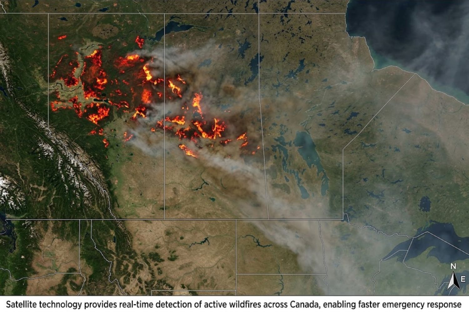
Canada faces a wildfire crisis that has fundamentally changed how we think about emergency response. But unlike traditional disasters that demand more firefighters or equipment, Canada’s solution is uniquely tech-driven. Artificial intelligence, satellite networks, advanced sensors, and real-time data systems are now the front line of defense against fires that once seemed impossible to control.
This shift matters beyond Canada’s borders. When over 830 wildfires burn simultaneously across the country, sending smoke as far as New York City and impacting millions of Americans, it’s clear that technology solutions developed in Canada today become critical infrastructure for North America tomorrow.
In this guide, we’ll explore how technology is reshaping wildfire management, what tech solutions are actually working, where innovation is headed, and why this matters for USA communities watching the smoke roll in.
Why Canada’s Wildfire Problem Has Become a Tech Crisis
The Scale of the Problem
The numbers are staggering. In 2023, Canadian wildfires burned more than 2.7 million hectares—eight times the average of the previous three decades. Canada experiences roughly 8,000 wildfires annually, but climate change has transformed the problem entirely.
What makes this a technology crisis rather than just an environmental crisis? It’s simple math: you cannot respond to 800+ simultaneous fires with traditional methods. There aren’t enough firefighters, aircraft, or crews. The only viable solution is early detection, predictive intelligence, and resource optimization through technology.
The Canadian Interagency Forest Fire Centre now tracks wildfires using digital systems that update daily. But daily updates aren’t fast enough when a fire can double in size overnight.
Why Traditional Response Fails at Speed
Historically, Canada’s wildfire management relied on:
- Visual spotting from aircraft
- Ground-based observer networks
- Reactive deployment of suppression crews
Each of these methods has a fatal flaw: they operate on human timescales. A spotter sees smoke. That information travels through radio, dispatch, and planning before crews mobilize. By then, hours have passed. A fire that was 100 hectares is now 500.
In 2023, more than 82 wildfires were burning out of control simultaneously. No amount of traditional firefighting could handle that scale.
This is where technology doesn’t just help—it becomes the only viable approach.
The Tech Imperative
Canada’s government recognized this reality. The Canadian Space Agency, Natural Resources Canada, and Environment and Climate Change Canada partnered to build infrastructure that treats wildfire response as a data problem, not just a resource problem.
The strategy: detect fires faster, predict where they’ll spread, optimize where to send limited resources, and share real-time information with every stakeholder simultaneously.
That’s not firefighting. That’s intelligent systems design.
How Artificial Intelligence Is Detecting Fires Before They Become Catastrophes
AI-Powered Camera Networks: The First Line of Defense
One of the most effective technologies emerging is AI-enabled cameras that can detect wildfire smoke faster than human observers or traditional satellites.
SenseNet, a British Columbia-based company, developed a system that integrates:
- AI-enabled thermal cameras that detect heat signatures
- Gas sensors that detect smoke compounds before visible smoke appears
- Satellite data integration to confirm fire location
- Predictive analytics to estimate fire behavior
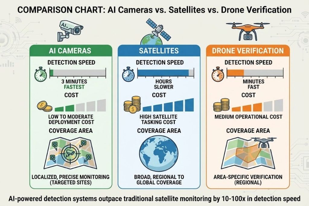
The result? Fire detection in as little as 3 minutes—often before smoke becomes visible.
Traditional satellites have overpass times measured in hours. A fire starting at noon might not be detected by satellite until evening. By then, it’s become a major incident.
SenseNet’s technology has detected over 2,700 fires across current deployments in British Columbia and Alberta. The company is expanding to 10 communities across both provinces, with plans for national and international scale.
What makes this AI-powered, not just algorithmic? The system learns from deployment data. As it monitors more fires, it improves at distinguishing wildfire smoke from agricultural burns, dust storms, and cooking fires—all things that produce thermal signatures but require different responses.
Machine Learning Fire-Spread Prediction
Detecting a fire quickly is step one. Predicting where it will go is step two.
Researchers at the University of Moncton are developing AI algorithms that analyze satellite imagery in real time to predict fire spread. The system combines:
- Current fire location from satellite and camera feeds
- Weather data (wind direction, speed, humidity, temperature)
- Terrain mapping (slope, vegetation density, fuel load)
- Historical fire behavior from the Canadian Fire Spread Dataset
The result is a prediction of where the fire will spread in the next 6, 12, and 24 hours.
This matters enormously for evacuation planning. Instead of evacuating an entire region speculatively, emergency managers can use fire-spread predictions to evacuate only areas in the fire’s predicted path. This reduces chaos, improves resource allocation, and saves lives.
The Canadian Fire Spread Dataset, released in 2024, contains fire progression maps for all wildfires larger than 1,000 hectares from 2002-2021. This historical data is training the next generation of AI models.
Real-World Impact: SenseNet’s Detection Performance
Numbers matter in tech. Here’s what the data shows:
- Detection speed: 3 minutes (vs. hours for traditional methods)
- Fires detected: 2,700+ across deployments
- Current deployment: 10 communities (expanding)
- Cost impact: Municipalities save thousands to millions per early detection
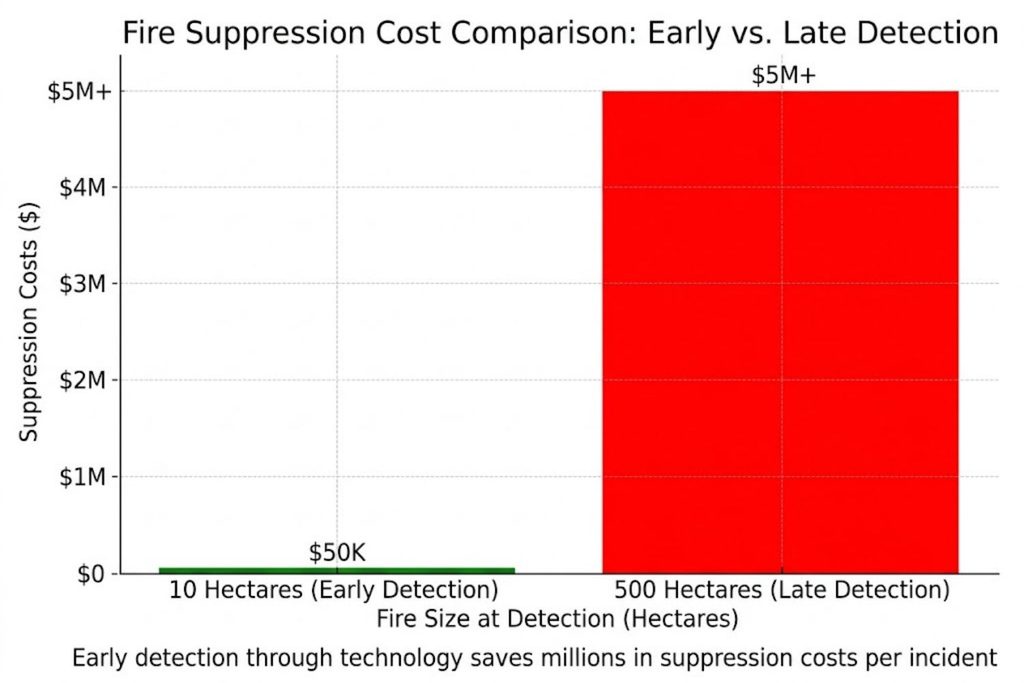
When you detect a 10-hectare fire instead of a 500-hectare fire, you’ve prevented enormous costs and risk.
Satellite Technology: Canada’s Eyes in the Sky
Current Satellite Monitoring Systems
Right now, Canada relies on satellites not designed specifically for wildfire monitoring. These include:
- NOAA satellites (US-based, general Earth observation)
- Sentinel satellites (European Space Agency)
- GOES satellites (meteorological satellites with thermal sensors)
These satellites work, but with limitations:
- Overpass frequency: Limited revisits per day
- Optimization: Built for weather, not fire specifics
- Thermal resolution: Adequate, but not optimal for wildfire detection
- Cost: Developed for other purposes; wildfire monitoring is secondary
In 2023, when over 200 Canadian wildfires raged simultaneously, these satellites provided daily updates. But daily updates are a lagging indicator when you need real-time decisions.
Satellite technology also captured unprecedented phenomena. During Alberta wildfires, the GOES-18 satellite observed pyrocumulonimbus clouds—fire-generated storm clouds that reach the stratosphere. This visualization, while dramatic, also demonstrated how satellite data reveals fire behavior that ground observers cannot see.
WildFireSat: Canada’s Game-Changing Mission (2029)
In 2022, the Canadian government approved funding for WildFireSat, the first government-owned satellite mission specifically designed to monitor active wildfires.
Here’s why this matters:
Purpose-Built Design:
- Optimized thermal imaging specifically for wildfire detection
- Microbolometer-based imaging sensor (uncooled, efficient, cost-effective)
- Daily monitoring of all active Canadian wildfires
- Real-time data accessible to public and fire managers
Launch Timeline: 2029 (5 years away at current date)
Expected Impact:
- Enable wildfire managers to identify which fires have outbreak potential
- Reduce reconnaissance flights (saving resources, reducing risk to pilots)
- Support air quality forecasting by tracking smoke dispersion
- Position Canada as a global leader in space-based wildfire technology
Technical Innovation: Unlike traditional cooled thermal detectors (expensive, power-hungry), WildFireSat uses microbolometer technology—simpler, lighter, and more practical for satellite applications.
The cost-benefit analysis, published in 2024, models substantial returns on investment when factoring in:
- Reduced suppression costs from earlier detection
- Lives saved through better evacuation planning
- Infrastructure protection through resource optimization
- Air quality improvements in US communities
This satellite will be fully integrated with ground-based systems, AI analytics, and public data portals.
How Satellite Data Powers Evacuation Planning
Here’s the practical workflow:
- Satellite detects active fire (coordinates, thermal intensity)
- AI algorithm predicts spread (using satellite data + weather + terrain)
- Dispatch center receives prediction model (visual map of likely fire path)
- Evacuation orders are issued to specific communities
- Resources are pre-positioned to areas most likely to need suppression
- Public receives real-time data (some provinces share satellite imagery directly)
During the 2023 Nova Scotia wildfires, over 16,000 people evacuated. Using predictive technology, emergency managers could focus evacuation efforts rather than issuing blanket orders.
The result: faster evacuations, fewer false alarms, and better public trust in emergency systems.
The Integration of 5G, Drones, and Autonomous Systems
Real-Time Data Networks for Firefighters
Data is worthless if it doesn’t reach decision-makers in time.
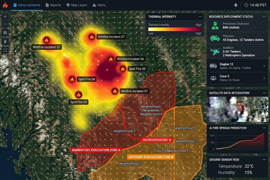
Canada is deploying 5G-enabled camera networks that transmit real-time wildfire data to command centers. Unlike older systems that store data for later analysis, 5G enables live feeds that support:
- Situational awareness (where is the fire now?)
- Resource deployment (where should we send crews?)
- Evacuation updates (which roads are safe?)
- Interagency coordination (firefighters, police, medical, public works)
One example: Pano makes AI-enabled cameras that detect smoke through 5G connections and share data instantly. Combined with provincial wildfire services, this creates a unified operating picture.
The advantage over satellite or aircraft spotting: 5G-enabled cameras provide continuous monitoring without waiting for satellite overpass times or sending aircraft into dangerous conditions.
Drone Deployments: Autonomous Response
Several companies are piloting autonomous systems:
Rain Aerospace has been testing autonomous helicopters that can carry fire suppressant and deploy it without human pilots. The advantages:
- Reduces pilot risk in extreme conditions
- Enables operations 24/7 (no pilot fatigue)
- Precise payload delivery based on AI targeting
- Faster response than crewed aircraft
Surveillance drones from multiple vendors are now standard in Canadian wildfire response. They provide:
- Real-time video feed to command centers
- Thermal imaging (heat detection through smoke)
- High-resolution mapping of fire perimeter
- Damage assessment in evacuation zones
These aren’t science fiction. They’re deployed in active incidents.
Why Integration Matters More Than Individual Tech
Here’s what makes the difference:
A great AI algorithm is useless if satellite data can’t reach it. A perfect satellite image is useless if drones can’t verify it. Real-time drone footage is useless if 5G networks can’t transmit it. Accurate predictions are useless if dispatchers can’t act on them.
Canada’s emerging approach treats wildfire response as a system:
Satellite Detection → AI Prediction → 5G Transmission → Drone Verification →
Dispatch Action → Ground Response → Real-time Adjustment
Each component feeds the next. A fire detected by satellite is verified by drone. Drone feed confirms AI predictions. Predictions direct resource allocation. Resources adjust based on live feedback.
This is systems thinking applied to disaster response.
Why Canadian Wildfires Matter to USA Readers
Cross-Border Smoke and Air Quality Impacts
When Canadian fires burn, Americans breathe the consequences.
In 2023, smoke from Canadian wildfires turned New York City’s sky orange and sent air quality to hazardous levels. Similar impacts hit Baltimore, Boston, Minneapolis, and St. Louis. The Ohio Valley experienced reduced visibility and poor air quality for weeks.
In July 2026, more than 830 Canadian wildfires sent smoke across the northern US during an extreme heat spell, creating a double hazard: dangerously high temperatures plus unhealthy air.
This isn’t occasional. It’s structural. Canada’s boreal forests generate massive smoke plumes when burning. Wind patterns carry that smoke directly across the border.
Why technology matters: Better detection in Canada means earlier warning in USA communities. Accurate fire-spread predictions allow US air quality forecasters to issue warnings 24-48 hours earlier. Evacuation planning in Canadian border regions prevents refugee surges into US communities.
Technology isn’t just saving Canadian lives. It’s protecting American public health.
Technology Transfer and Innovation
The technology developed to fight Canadian wildfires is transferable to the Western US.
When SenseNet deploys AI camera networks in British Columbia, the same technology can be adapted for California, Oregon, and Washington—where wildfire seasons are equally severe.
When Canadian researchers develop fire-spread prediction algorithms using the Canadian Fire Spread Dataset, those models can be retrained on US fire data.
WildFireSat, launching in 2029, could provide international coverage. US wildfire managers are already discussing how to integrate WildFireSat data with existing systems.
Innovation flows both ways. Technology developed in California influences Canadian approaches. The best practices of one country’s fire management system become the foundation of another’s.
Lessons for US Wildfire Management
The US approach to wildfire management has historically been more fragmented:
- Federal lands managed by USDA Forest Service and Interior Department
- State management varies widely
- Private land management falls to property owners
- Interagency coordination happens ad-hoc
Canada’s coordinated tech approach offers lessons:
- Centralized data systems reduce redundancy
- Public data access improves community preparedness
- Satellite infrastructure is a shared asset, not a luxury
- AI prediction changes response from reactive to proactive
The NOAA satellites currently used for US wildfire monitoring are excellent, but they’re not optimized for wildfire (unlike WildFireSat). The US is quietly learning from Canada’s approach and considering similar dedicated satellite infrastructure.
Barriers to Tech Adoption in Wildfire Management
Technology isn’t magical. Real barriers exist to implementation.
The Cost Challenge
A single satellite costs $100+ million. AI systems require constant retraining. 5G network expansion requires infrastructure investment.
Small municipalities can’t afford this technology alone. Even provinces struggle with funding large-scale deployments.
Solution emerging: Shared infrastructure models where provincial and federal governments co-invest in systems serving all communities. WildFireSat is funded federally but benefits all provinces.
Private-sector solutions (SenseNet, Pano, etc.) offer another path: subscription models where municipalities pay per camera or per alert, spreading costs.
Data Interoperability and Standardization
Here’s a practical problem: A fire detection system built by one company might use data formats incompatible with another company’s prediction system. A satellite operator might use different coordinate systems than ground-based systems.
When lives depend on split-second information sharing, incompatibility is fatal.
Canada is addressing this through standards development:
- Canadian Wildland Fire Information System provides standardized data
- National standards for thermal imaging data
- Interoperability protocols for emergency management systems
But this work is ongoing. Legacy systems built over decades don’t automatically talk to new AI systems.
Training and Operational Integration
A firefighter trained 20 years ago doesn’t automatically understand how to use AI predictions or interpret satellite imagery.
Canada is investing heavily in training:
- Wildfire management agencies are updating protocols
- Dispatchers learn to interpret predictive models
- Field commanders understand real-time data feeds
But cultural change is slow. New technology only works if operators trust it and know how to use it.
The Future of Wildfire Technology
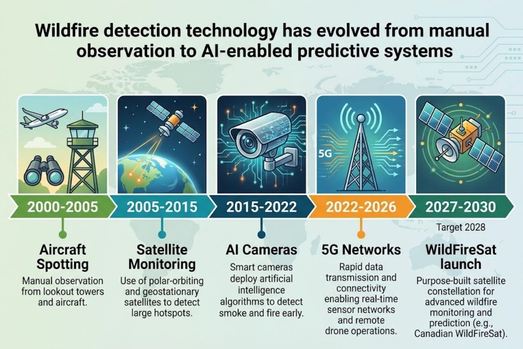
What’s next? The technology frontier is already visible.
Multi-Sensor Fusion Systems
Instead of relying on one technology (satellite OR camera OR prediction model), the future integrates everything simultaneously.
Imagine a system where:
- Satellite provides wide-area detection
- Ground cameras verify and provide detail
- Weather data feeds fire-behavior models
- Thermal drone imaging confirms satellite hot spots
- AI synthesizes all inputs into a unified prediction
- Public-facing app shows evacuation zones
This isn’t hypothetical. Components exist today. Integration is the challenge.
Predictive Analytics at Scale
Current prediction models work well at regional scale. Future versions will:
- Predict fire starts before ignition (based on weather, fuel load, ignition sources)
- Forecast fire seasons weeks in advance
- Identify high-risk communities for year-round monitoring
- Optimize resource pre-positioning (having crews in areas about to experience fire season)
This shifts wildfire management from emergency response to strategic planning.
Public Data Access and Community Resilience
WildFireSat data will be publicly accessible. This enables:
- Community-level fire risk monitoring
- Property owners planning defensible space based on actual risk
- Insurance companies pricing based on real data (not models)
- Researchers building better prediction systems
- Tech startups creating applications we haven’t imagined yet
When data is public, innovation accelerates. The best wildfire technology of 2030 might be built by someone who hasn’t started coding yet.
KEY TAKEAWAYS
✓ Canada’s wildfire crisis is now a technology problem — Traditional suppression methods can’t handle 800+ simultaneous fires
✓ AI-powered detection systems work — SenseNet’s technology detects fires in 3 minutes vs. hours for traditional methods
✓ Satellite technology is evolving — WildFireSat (2029) will be the first purpose-built wildfire monitoring satellite
✓ Integration matters more than individual tech — Real systems combine satellites, AI, drones, 5G, and ground teams
✓ US communities are directly impacted — Canadian wildfire smoke affects air quality and emergency systems across North America
✓ Technology transfer is accelerating — Solutions developed in Canada are being adapted for Western US wildfires
✓ Adoption barriers are solvable — Cost, standardization, and training are challenges with emerging solutions
✓ The future is predictive, not reactive — Next-generation systems will predict fires before they start
FAQ SECTION
Q1: How does AI detect wildfires faster than satellites?
A: AI-enabled cameras continuously monitor specific areas and detect thermal signatures or smoke compounds in real time. Satellites require orbital positioning and have limited overpass frequency (hours). SenseNet’s system achieves 3-minute detection vs. satellite’s hours-to-days lag.
Q2: When will WildFireSat launch?
A: The Canadian Space Agency targets 2029 for WildFireSat launch. It will be the first government-owned satellite specifically designed for daily monitoring of all active Canadian wildfires.
Q3: Can US states use Canadian wildfire technology?
A: Yes. Technology like SenseNet’s camera systems and fire-spread prediction algorithms are transferable. WildFireSat data could eventually be shared internationally. Private companies serving Canadian provinces also operate in the US.
Q4: How far does Canadian wildfire smoke travel?
A: In 2023, smoke reached New York City (over 2,000 km away). Depending on wind patterns and fire intensity, smoke can affect air quality across the entire eastern US.
Q5: Why can’t we just use more firefighters to stop wildfires?
A: Scale makes traditional approaches impossible. 830 simultaneous fires require thousands of crews that don’t exist. Technology enables resource optimization by predicting fire behavior and deploying crews where they’re most needed.
Q6: What’s the cost difference between detecting a fire at 10 hectares vs. 500 hectares?
A: Early detection costs roughly $10,000-50,000 in prevention. Late detection can cost millions in suppression, evacuation, and recovery. Technology that enables early detection pays for itself immediately.
Q7: How does 5G improve wildfire response?
A: 5G enables real-time data transmission from cameras and drones to command centers. Older systems relied on periodic updates. Real-time feeds allow dispatchers to make faster, better-informed decisions.
Q8: Will autonomous drones replace human firefighters?
A: No. Drones augment human firefighting by reducing pilot risk, enabling 24/7 operations, and providing real-time data. Ground crews will always be essential for structure protection and evacuation support.
Q9: How do machine learning models improve fire-spread prediction?
A: Models train on historical fire data (2,700+ fires in datasets), weather patterns, and terrain analysis. As they process more fires, they identify patterns humans miss, improving accuracy.
Q10: Can wildfires be predicted before they start?
A: Next-generation systems will identify high-risk conditions (weather, fuel load, ignition sources) and flag communities needing increased monitoring. True pre-ignition prediction is emerging.
Q11: Who can access WildFireSat data?
A: Data will be publicly accessible to fire managers, researchers, emergency planners, and the public. Public access enables innovation and community awareness.
Q12: How much does early wildfire detection cost communities?
A: SenseNet’s model is deployment-based. Municipalities pay per camera or per alert. Cost ranges from $50,000-500,000 depending on coverage area—far less than one major fire suppression operation.
Q13: Why is microbolometer technology important for WildFireSat?
A: Microbolometers are uncooled thermal detectors that are cheaper, lighter, and more power-efficient than traditional cooled detectors. This makes them ideal for satellite applications and reduces mission costs.
Q14: How do fire-spread predictions affect evacuation planning?
A: Instead of evacuating entire regions speculatively, accurate predictions identify specific communities in the fire’s path. This reduces chaos, improves resource allocation, and prevents unnecessary displacement.
Q15: What’s the relationship between climate change and Canadian wildfires?
A: Canada is warming faster than the global average, creating hotter, drier conditions. This extends fire seasons, increases fire frequency, and creates more intense burns. Technology can’t prevent this trend—only respond more effectively.